
How to Build a Stanley Park Day Without Trying to See Everything
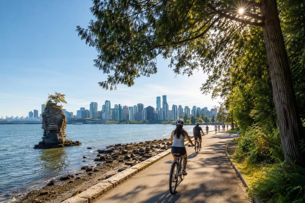
For a first visit, Stanley Park rewards selective planning. Its waterfront circuit, forest paths, wetlands, gardens, beaches, recreation facilities, and attractions cover enough ground that trying to “do the park” in one hurried pass often means enjoying very little of it.
For a first visit, begin with five possibilities:
- Travel part or all of the Stanley Park Seawall.
- Stop at Brockton Point for the Indigenous artworks and lighthouse.
- See Lions Gate Bridge from elevated Prospect Point.
- Add Lost Lagoon or a short interior forest walk.
- Finish at a beach if time, weather, and daylight allow.
You do not need all five. A short Lost Lagoon or Brockton Point walk can fill an hour. A half-day suits a Seawall-focused ride or a mixed walking route. A full day can combine the waterfront, one interior nature stop, lunch, and either a paid attraction or seasonal activity.
The central question is not how many things to do in Stanley Park you can fit onto a list. It is which route fits your time, energy, interests, and preferred pace.
Start with the Stanley Park experiences that fit your visit
Stanley Park’s signature experience is the waterfront. Traveling the Seawall—whether for one section or the complete park circuit—brings changing views of Coal Harbour, Burrard Inlet, the North Shore, Lions Gate Bridge, English Bay, and the city. It also connects many of the park’s recognizable landmarks.
A complete circuit is not necessary for a satisfying short visit. Brockton Point concentrates several worthwhile eastern-side stops in one area, while Lost Lagoon offers a straightforward nature outing near the Georgia Street entrance. Either can be more rewarding than racing around the entire perimeter.
Prospect Point belongs on the shortlist when elevated bridge and harbour views matter more than staying beside the water. It is not simply another flat Seawall stop: approaching it from waterfront level can add a substantial climb. Visitors who would rather avoid that effort can remain near the shoreline and still have a substantial park experience.
It can anchor a family outing, add a major indoor component in unsettled weather, or appeal to visitors interested in marine life. Admission is separate from park entry, and current tickets, prices, hours, exhibits, and entry conditions should be checked directly with the aquarium before visiting.
Outdoor trails, beaches, gardens, landmarks, viewpoints, Lost Lagoon, and the Seawall can generally be enjoyed without an admission charge.
Stanley Park also supports swimming, picnicking, tennis, dining, golf, independent exploration, organized tours, and seasonal train rides. Availability, reservations, equipment requirements, and operating periods vary, so use the City of Vancouver’s activity overview as a starting point and then check the relevant operator or facility.
A practical first decision is:
- One to two hours: Choose Lost Lagoon, Brockton Point, or one short waterfront section.
- Half-day: Make the Seawall the main event, usually by bicycle or through a selected walking route.
- Full day: Combine waterfront scenery, forest or wetland time, lunch, and one major attraction or seasonal activity.
- Budget-focused day: Build the outing around free outdoor sights and bring food.
- Family day: Select one anchor attraction and add only one or two nearby outdoor stops.
Hours, admission policies, reservations, and seasonal operations can change. Avoid building a rigid itinerary around an old schedule, even when the landmark or facility still appears on a current map.
Walk or cycle the Stanley Park Seawall
The Stanley Park circuit is commonly described as approximately 9 to 10 kilometres. That is the loop around the park, not the entire Vancouver waterfront system. Published figures of 22 or 28 kilometres refer to broader seawall measurements and should not be used as the distance for one Stanley Park circuit. Supported estimates place the loop at roughly two to four hours on foot or one to one-and-a-half hours by bicycle before long sightseeing stops (compare the route distance and timing estimates).
These are planning ranges, not guaranteed completion times. They do not include an aquarium visit, a sit-down meal, an extended beach stop, or a significant interior detour.
Travel times vary because visitors define and experience the circuit differently. One person may keep a steady pace and stop twice. Another may photograph the lighthouse, read interpretation at Brockton Point, leave the waterfront for Prospect Point, eat lunch, and pause at Third Beach. Congestion, weather, temporary detours, bicycle comfort, children, and route-finding can all extend the outing.
Walk if you want detail and flexibility. Walking makes it easier to read signs, examine viewpoints, take photographs, and turn one appealing section into the entire outing. It is the better choice when completing the perimeter is unimportant or when you want to focus on one side of the park.
Cycle if you want coverage. A bicycle makes the waterfront circuit more manageable within a half-day and can leave time for a lagoon, beach, meal, or short interior stop. The tradeoff is that cyclists must pay closer attention to direction, lane use, passing space, posted restrictions, and changing conditions.
Travel guides report separate pedestrian and bicycle space along the Seawall and counterclockwise bicycle travel. Treat that as advance orientation, not a substitute for current instructions: follow posted signs and check for closures, detours, lane changes, and applicable bicycle or e-bike rules before starting (review the reported cycling layout).
The waterfront route is generally less demanding than climbing from shoreline level toward Prospect Point. Even so, “mostly level” does not mean effortless for every visitor. Distance, wind, crowds, frequent stops, and the ride to and from a rental shop all add to the day.
Bicycle-rental shops are commonly found near Denman and Georgia streets outside the park. Confirm opening hours, inventory, bicycle type, locks, helmets, children’s equipment, adaptive options, deposits, damage policies, prices, closing time, and return terms directly with the operator.
Most importantly, do not promise yourself a complete loop plus Brockton Point, Prospect Point, the aquarium, lunch, Lost Lagoon, and a beach within a rigid two-hour window. Two hours can support a focused bicycle ride with brief stops or a worthwhile waterfront walk. It is not a dependable full-park timetable.
Choose the best waterfront landmarks and viewpoints
The clearest way to understand Stanley Park’s waterfront stops is geographically. Beginning near Coal Harbour on the eastern side and continuing around the perimeter toward English Bay creates a natural sequence rather than an unranked checklist.
Coal Harbour and Brockton Point: Approaching from downtown or the West End, the eastern waterfront provides marina, skyline, harbour, and mountain views. Brockton Point is the first major cluster for many visitors, combining the pole display, Brockton Point Lighthouse, and nearby shoreline scenery.
The Brockton Point display is a collection of Indigenous artworks that includes replicas rather than a preserved set from one original village site. Use the onsite labels and interpretation to learn about individual works, artists, and origins rather than applying one generalized explanation to every carving (review the documented context for the display).
Brockton Point Lighthouse provides a distinct harbour-side landmark and a natural photography stop. Even visitors skipping the complete circuit can combine the lighthouse, pole display, and surrounding water views in a compact outing.
Girl in a Wetsuit and the northeastern shore: Continuing around the water brings views into Burrard Inlet and the recognizable Girl in a Wetsuit sculpture. It works best as a brief landmark stop rather than a destination requiring a large block of time.
Prospect Point: Prospect Point is the elevated choice for views of Lions Gate Bridge, the North Shore, harbour traffic, and passing ships. Its advantage is height; its disadvantage is that the height must be gained.
A Seawall traveler should not assume that Prospect Point is an effortless waterside pull-off. Depending on the approach, reaching it may require a deliberate route change and a substantial climb. Include it when the bridge view is a priority and your route, energy, and schedule support the detour. Skip it without regret when your goal is an easier waterfront circuit.
Siwash Rock and the western side: Siwash Rock is one of the western shoreline’s recognizable natural landmarks. It can be incorporated into a selected western Seawall walk or a longer circuit and provides a visual change from the beaches, forested slopes, and open water around it.
Third Beach: Farther around the western side, Third Beach is useful as a genuine stopping point rather than merely another item to photograph. It is commonly recommended for sunset, but no itinerary can promise colour, clear skies, or an unobstructed horizon. The beach remains suitable for a rest or unhurried finish when the light is subdued.
A logical photography sequence is:
- Coal Harbour or Brockton Point for harbour and skyline context.
- Brockton Point Lighthouse for a defined architectural landmark.
- Prospect Point for Lions Gate Bridge and North Shore views.
- Siwash Rock for the western shoreline.
- Third Beach for late-day water and sky.
That sequence identifies locations, not guaranteed conditions. Fog, rain, haze, seasonal daylight, crowds, and temporary access changes can alter every photograph.
Go beyond the Seawall for wetlands, forest trails, and gardens
The Seawall is only one version of Stanley Park. Interior routes replace continuous harbour, skyline, and mountain views with forest, wetlands, quieter paths, and seasonal planting. They work both as complements to the waterfront and as alternatives when a complete circuit does not fit.
Lost Lagoon is the most convenient short nature option for many visitors arriving from downtown. It sits near the Georgia Street entrance, so you can reach it without committing to a deep interior route. The circuit is described as just under 2 kilometres and approximately a 30-minute walk, although that duration is an estimate rather than a promise (see the published route description).
Lost Lagoon works particularly well when you have about an hour, want a gentler start to the day, or need an alternative to the full Seawall. Photography, bird observation, route-finding, and pauses can extend the outing, while a partial circuit can shorten it.
Beaver Lake offers a quieter wetland destination deeper in the interior path network. Reaching it changes the character of the visit: water remains part of the landscape, but vegetation encloses the experience rather than framing a broad shoreline. It is better suited to visitors prepared to navigate connecting paths than to someone expecting a single obvious promenade.
Stanley Park contains more than 27 kilometres of pathways, and its interior walks can be combined rather than treated as one continuous prescribed route (see Destination Vancouver’s park overview). That flexibility is useful, but it creates more navigational complexity than following the waterfront.
Consult a current digital or printable City map before connecting Lost Lagoon, Beaver Lake, gardens, and forest paths. The available summaries do not establish a dependable turn-by-turn route for every possible combination, and temporary work can change the most convenient connection.
Garden stops can add variety without becoming the focus of an entire day. The Rose Garden and the rhododendron and azalea plantings are seasonal attractions. Flowering periods and conditions vary with weather, maintenance, and the timing of a visit, so do not plan around a guaranteed display.
Birds and other wildlife may add interest around the wetlands and shoreline, but sightings are never assured. Observe without approaching or disturbing animals, and let the landscape—not a wildlife checklist—justify the route.
Choose the interior when you want:
- Forest and wetland atmosphere instead of continuous open water
- A shorter nature walk near the entrance
- A break from busier waterfront sections
- Seasonal garden interest
- A route assembled from smaller path segments
Choose the Seawall when straightforward navigation, broad views, recognizable landmarks, or a continuous circuit matters more.
Plan a family visit around one anchor attraction
A successful family visit usually has one anchor: the Vancouver Aquarium, a beach outing, or a confirmed seasonal train ride. Trying to combine every playground, pool, landmark, train, trail, and aquarium exhibit can turn the park into a series of deadlines.
The Vancouver Aquarium is inside Stanley Park and requires separate admission. Because it can occupy a substantial part of the day, pair it with one nearby outdoor stop rather than assuming it will fit between a complete Seawall circuit and several beaches. Check the aquarium directly for current tickets, prices, opening hours, entry rules, and available exhibits (confirm the attraction’s location and ticketed status).
Outdoor family possibilities include playgrounds, Second Beach, Third Beach, picnic areas, and short walks at Lost Lagoon or Brockton Point. The outdoor pool, water-play facilities, miniature train, concessions, and some recreation are seasonal or schedule-dependent. Their appearance on a map does not prove that they will operate on your date.
The miniature train follows a short forest track. It is an attraction, not transportation connecting the aquarium, beaches, Prospect Point, and the park’s other major sights. Build the day around a train ride only after confirming the relevant event, ticket arrangements, and operating calendar.
Families with older children or teenagers might prefer pitch-and-putt, tennis, swimming, cycling, or a picnic. Equipment, admission, reservations, and seasonal conditions should be confirmed where relevant.
Two manageable combinations are:
- Aquarium plus outdoors: Visit the aquarium, then add Brockton Point, a playground, or a short Lost Lagoon walk according to energy and weather.
- Short walk plus seasonal play: Explore Lost Lagoon or Brockton Point, then continue to a confirmed train event, pool, water-play facility, or beach activity.
Do not infer wheelchair or stroller accessibility merely because a path is paved or appears on a general map. Families and travelers with mobility requirements should check current official information about grades, stairs, curb transitions, washrooms, construction, and temporary detours before choosing a route.
Use a one-hour, half-day, or full-day itinerary
The following durations are editorial planning estimates, not guarantees. Add time for photographs, congestion, route changes, hills, meals, attraction queues, children, weather, and temporary detours.
One hour: Lost Lagoon
Walk part or all of the lagoon circuit, pausing for views or bird observation. This is the clearest short nature plan near the park entrance. Do not add the complete Seawall.
One hour: Brockton Point
Concentrate on the pole display, onsite interpretation, lighthouse, and harbour views. This gives a first-time visitor several distinctive sights without pretending that one hour is enough for the park.
Two hours: selected waterfront walk
Choose one section of the Seawall and turn around or leave the route when time requires. Brockton Point and the eastern waterfront suit landmark-focused visits; a western section can combine Siwash Rock with beach time. If the route is not circular, reserve enough time for the return.
Two hours: focused bicycle ride
A bicycle can cover a larger portion—and under suitable conditions possibly all—of the circuit, but stops must remain brief. Treat a complete loop as conditional on pace, rental logistics, congestion, and route conditions rather than as a requirement.
Half-day cycling option
Enter from the Coal Harbour or Georgia Street side, follow the current cycling direction, and pause at Brockton Point. Continue around the waterfront, selecting only the viewpoints that matter most. Add Lost Lagoon near the beginning or end if your pace allows, or finish with a beach break. If Prospect Point is essential, account explicitly for the route change and climb.
Half-day walking option
Combine Lost Lagoon with a garden or short forest segment, then add a limited portion of the waterfront. For example, use the lagoon as the nature component and Brockton Point as the landmark component. This provides contrast without turning the perimeter into a race.
Full-day cycling framework
Begin with the Seawall by bicycle, allowing extra time for selected stops and rental formalities. After returning the bicycle or completing the ride, choose one substantial addition: the aquarium, a confirmed seasonal activity, or an interior nature walk. Include lunch and finish at Third Beach only if your location, energy, daylight, and weather make the transfer practical.
Full-day walking framework
Do not treat the entire waterfront, aquarium, Beaver Lake, gardens, and Third Beach as a single compulsory sequence. Instead, choose a longer waterfront section or an interior route as the main walk. Add one attraction, lunch, and one nearby secondary stop. A western beach finish works best when the day’s earlier route already leads in that direction.
These full-day frameworks are menus, not promises that every component will fit. Movement between the eastern waterfront, aquarium area, interior paths, and western beaches takes time even before attraction queues, meals, and rest stops are considered.
Free-day alternative
Build the outing from Brockton Point, Lost Lagoon, forest paths, gardens, Siwash Rock, viewpoints, and beaches. Include Prospect Point only if the route and climb fit your group. Bring a picnic and choose outdoor stops that connect naturally instead of crossing the park repeatedly.
A partial route is not a failed full route. It is often the better itinerary.
Reach Stanley Park without making transportation the whole day
Stanley Park can be reached and explored on foot, by bicycle, by public transit, or by car. Taxis, rideshares, sightseeing tours, and other arranged transportation provide additional options. Visitors staying downtown do not automatically need a vehicle.
Walking or cycling is especially practical from the West End and Coal Harbour. From Canada Place, published estimates put the journey to the park entrance at about 30 minutes on foot or 10 minutes by bicycle, before allowing for personal pace, traffic signals, crowds, or stops (see the published access estimates).
Bus 19 is repeatedly identified as serving Stanley Park, but its current route, stops, frequency, fares, and service alerts should be confirmed with TransLink. Public transit reaches the park; it should not be imagined as a vehicle continuously circulating among every beach, viewpoint, trail, and attraction. A substantial walk may still separate the most useful stop from your destination.
The City of Vancouver provides directions, parking information, and digital and printable maps showing major sites and trails through its Stanley Park transportation and map hub. Download or screenshot a map before leaving if you expect limited data service or plan to combine interior paths.
Drivers should check current road access, restrictions, parking locations, payment rules, prices, and likely availability before departure. A car can reduce the effort required to approach the park, but parking searches and road patterns can introduce their own constraints.
Bicycle rentals are commonly available near Denman and Georgia streets outside the park. Compare equipment, opening hours, return deadlines, deposits, and weather policies rather than selecting a shop solely because it is closest.
Use TransLink and City notices—not a general travel article—for same-day operations.
Build in food, beaches, picnics, and slower stops
Visitors can find restaurants, seasonal concessions, and food carts associated with Stanley Park, but current venues, locations, opening hours, and availability require confirmation. Prospect Point and the Teahouse area are useful geographic reference points, not guarantees that a particular service will be open when you arrive.
A packed picnic is the most flexible alternative. It removes the need to reach a restaurant at a precise time and works particularly well for a beach-, lagoon-, or garden-focused visit. Carry enough water for the distance you plan to cover and leave room in the schedule for food and washroom breaks.
A commercial travel guide reports that designated picnic areas may require reservations while some tables are available on a first-come, first-served basis. Groups should verify the current City rules for their intended site before organizing an event or relying on a particular table (review the reported picnic distinction).
Second Beach and Third Beach serve somewhat different planning purposes:
- Second Beach is associated with family recreation and a seasonal outdoor pool, along with nearby play opportunities.
- Third Beach is commonly chosen for relaxing, taking a longer pause, and watching sunset when conditions cooperate.
Pool operation, water-play facilities, swimming notices, and beach conditions are live matters. Consult current official notices rather than relying on a general guide or an attraction symbol on a map.
Meals and beaches should be treated as itinerary components, not delays. A quiet picnic or beach pause can make a selected Seawall section feel complete. By contrast, rushing the entire circuit simply to say it was completed can leave no time to enjoy the places that made the route appealing.
Check live conditions before you leave
Stanley Park’s major landmarks and broad route choices are relatively stable. Operations are not. Before departure, check:
- Weather and relevant warnings
- Seawall closures, construction, and detours
- Road restrictions and event impacts
- Aquarium hours, tickets, and entry requirements
- Stanley Park Train events and ticketing
- Pool and water-play operations
- Restaurant and concession service
- Picnic reservation requirements
- Transit routes, fares, and alerts
- Parking access, payment rules, prices, and availability
- Tour schedules and cancellation terms
- Seasonal recreation and garden conditions
- Current accessibility information for the route and facilities you intend to use
Make the checklist actionable by consulting the relevant operator: TransLink for transit, the Vancouver Aquarium for admission and exhibits, and the City of Vancouver for maps, parking, park notices, train information, recreation facilities, and route updates. The City’s transportation hub links onward to digital maps, printable maps, directions, and parking information.
Summer weekends and special events may produce congestion or road restrictions, increasing travel time. Build flexibility into the day rather than scheduling every stop to the minute.
Gardens, swimming, the outdoor pool, water play, miniature train, concessions, and some tours are seasonal, weather-dependent, or tied to particular events. Verify each individually. An attraction appearing on a general overview does not mean it operates every day or throughout the year.
On a rainy day, the aquarium can provide a substantial indoor anchor. A short forest segment may also suit light rain, but path conditions, wind, visibility, maintenance, and closures should determine whether it remains appropriate.
Travelers using wheelchairs or strollers, and anyone with other mobility requirements, should consult current official accessibility information. General route descriptions do not verify grades, curb transitions, stairs, washrooms, construction barriers, or temporary detours.
Cyclists should check current direction, helmet, e-bike, lane, and closure rules rather than relying solely on older travel guides. Posted instructions and current City notices govern the ride on the day.
Begin same-day planning with the City’s Stanley Park maps and transportation information, then confirm any ticketed or seasonal activity directly with its operator.
The final planning choice is simple: do less, deliberately. Use a short Lost Lagoon or Brockton Point walk for a brief visit. Cycle when covering more of the waterfront matters. Use a full day to combine the Seawall with one interior or ticketed experience—not every possible stop. Leave room for a meal or beach, and check official maps, alerts, and seasonal schedules before departure.
Is Stanley Park free to visit?
The park itself and most outdoor experiences—including trails, beaches, gardens, landmarks, viewpoints, Lost Lagoon, and the Seawall—can generally be visited without an admission charge. Paid options include the Vancouver Aquarium, bicycle rentals, tours, pitch-and-putt, and some organized or seasonal activities. Parking and food may add costs (see the supported cost overview).
Check individual operators for current prices and booking requirements. Free park entry does not include admission to every attraction.
How long does it take to walk or cycle the Stanley Park Seawall?
Plan on roughly two to four hours to walk the approximately 9-to-10-kilometre park circuit, or about one to one-and-a-half hours to cycle it before long stops. Photographs, congestion, food, beaches, detours, and sightseeing can extend either estimate considerably.
Do not confuse the Stanley Park circuit with longer figures describing Vancouver’s broader seawall. If you have only two hours, choose a selected walking section or a focused bicycle ride rather than expecting to cover every landmark and attraction.
Is it better to walk or bike around Stanley Park?
Walk if you want close observation, frequent stops, and the freedom to cover only one section. Cycle if you want to make more of the waterfront circuit manageable within a half-day while retaining time for selected landmarks.
Neither option is universally better. The right choice depends on available time, bicycle confidence, weather, rental logistics, route conditions, and how often you expect to stop. Cyclists should follow current signs, direction instructions, closures, and detours.
What can families do in Stanley Park?
Families can visit the Vancouver Aquarium, walk around Lost Lagoon or Brockton Point, use playgrounds and picnic areas, spend time at Second or Third Beach, or consider pitch-and-putt, tennis, cycling, and swimming.
The outdoor pool, water play, miniature train, concessions, and some recreation are seasonal or schedule-dependent. Choose one anchor—such as the aquarium, beach, or confirmed train event—and pair it with one nearby outdoor activity instead of attempting everything in one visit.
Can I visit Stanley Park without a car?
Yes. Walking and cycling from the West End, Coal Harbour, and downtown are practical options, and public transit serves the park. Bus 19 is commonly identified as the relevant route, but current stops, frequency, fares, and alerts should be confirmed with TransLink.
Transit should not be expected to circulate among every major sight. Use a current City map to understand the distance between your stop and the aquarium, Brockton Point, beaches, viewpoints, or interior trails.