
How to Explore Vancouver’s False Creek Warehouse District
Start near Yaletown, Roundhouse station, see Engine No. 374, explore Hamilton and Mainland streets, then continue to David Lam Park or the False Creek seawall.
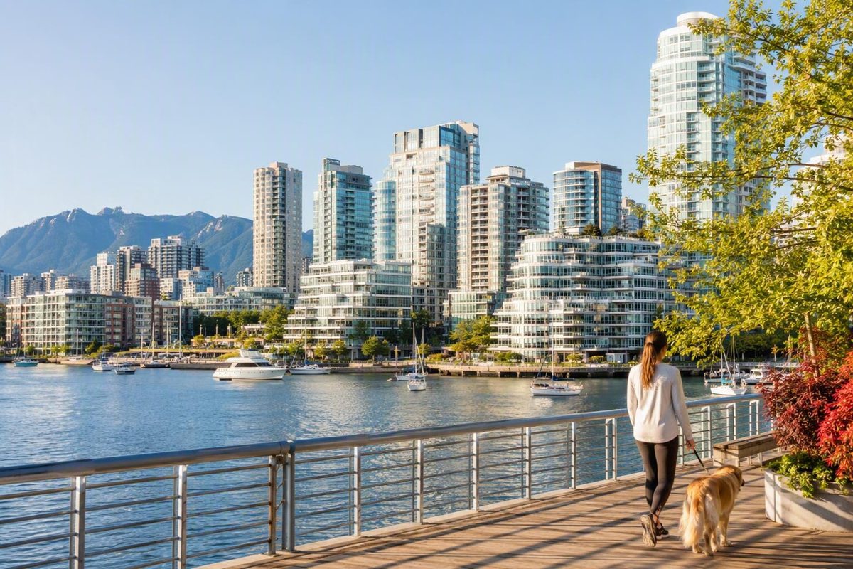
Yaletown is a distinct neighbourhood within the wider Downtown Vancouver area, set on the southern part of the downtown peninsula beside False Creek. Its mix of railway heritage, converted brick warehouses, residential towers, restaurants, parks, and waterfront paths makes it practical for many short, car-free sightseeing plans.
For a first visit, start near Yaletown–Roundhouse station, see the Roundhouse and Engine No. 374, explore the warehouse blocks around Hamilton and Mainland streets, and continue to David Lam Park or the False Creek seawall. The core sequence generally suits a two-to-three-hour outing; a meal, longer waterfront walk, or ferry connection can turn it into a half day.
Is Yaletown in Downtown Vancouver? The short answer
Yes. Yaletown is commonly considered a neighbourhood within Downtown Vancouver. It occupies part of the southern side of the downtown peninsula, beside the north shore of False Creek.
Descriptions sometimes appear inconsistent because downtown has two common meanings. Broadly, Downtown Vancouver includes several neighbourhoods on the peninsula, including Yaletown. In casual travel language, “downtown core” may refer more narrowly to the central business, shopping, office, and hotel district farther north. A guide can therefore describe Yaletown as beside the downtown core while still treating it as part of the wider downtown area. Destination Vancouver places Yaletown between False Creek and the downtown core.
That distinction matters when choosing accommodation. The label alone does not reveal whether the immediate setting is dominated by offices, shopping, restaurants, residential streets, or waterfront paths.
For orientation, landmarks are more useful than a disputed boundary line:
- False Creek and the seawall define the waterfront side of the neighbourhood.
- Yaletown–Roundhouse station is its named Canada Line stop.
- The Roundhouse and Engine No. 374 form the main railway-heritage focal point.
- Hamilton and Mainland streets are the practical centre of the converted-warehouse dining district.
- David Lam Park opens onto False Creek.
- BC Place and Rogers Arena are nearby toward the eastern side of the wider central area.
Yaletown orientation
- Is it downtown? Commonly, yes.
- Is it another name for all of Downtown Vancouver? No.
- What is it? One distinct central neighbourhood beside False Creek.
- Best map anchors: Yaletown–Roundhouse station, the Roundhouse, Hamilton and Mainland streets, David Lam Park, and the seawall.
- Nearby major venues: BC Place and Rogers Arena.
For most visitors, the terminology changes little about the practical experience. Yaletown is connected to the rest of the downtown peninsula by streets, transit, walking routes, and cycling infrastructure. The more useful question is whether its waterfront, warehouse, and dining setting suits the visit or overnight base you want.
Where Yaletown begins and ends
Yaletown does not have one universally accepted visitor boundary. False Creek is its clearest and most consistently identified edge, but published descriptions differ over how far the neighbourhood extends north, east, and west.
Depending on the source, proposed edges include Homer Street, Pacific Boulevard, Robson Street, Smithe Street, Richards Street, Carrall Street, and connecting or stepped lines involving several streets. Expedia, for example, describes Yaletown using False Creek, Homer Street, and Pacific Boulevard as reference points. That is useful for rough orientation, but it is only one published description—not a universally accepted perimeter. See Expedia’s boundary description.
Disagreement is greatest around the northern, eastern, and western edges. This is unsurprising for a neighbourhood whose identity is partly historical, partly commercial, and partly based on common usage. A hotel, restaurant, or residential building near an edge may be marketed as Yaletown even if another map assigns it to a neighbouring part of downtown.
For sightseeing, think of Yaletown as a group of connected places:
- The former railway area around the Roundhouse.
- The converted warehouse blocks around Hamilton and Mainland streets.
- The residential towers and public spaces between those blocks and False Creek.
- David Lam Park and the waterfront.
- Seawall connections toward George Wainborn Park and Coopers’ Park.
- The transition toward BC Place and Rogers Arena to the east.
Hamilton and Mainland streets are especially useful as the neighbourhood’s practical centre, not as formal boundaries. Their brick buildings, loading platforms, patios, restaurants, shops, and bars make Yaletown’s historical-commercial character easy to recognize.
Any visitor map should label its outline “approximate Yaletown area” and emphasize landmarks rather than implying a settled legal perimeter. Useful points to mark include:
- Yaletown–Roundhouse station
- Roundhouse Community Arts and Recreation Centre
- Engine No. 374
- Hamilton Street
- Mainland Street
- David Lam Park
- False Creek and the seawall
- BC Place
- Rogers Arena
This landmark-based approach is also more useful for route planning. “Close to downtown” says less than naming an actual starting point such as Waterfront Station, Robson Street, Gastown, or the West End. Walking comfort and duration depend on the endpoints, route, weather, intersections, luggage, and individual mobility.
From railway yards to waterfront towers
Yaletown’s appearance reflects several stages of development rather than one architectural period. The district grew around Canadian Pacific Railway activity, railyards, warehouses, transportation, and industry before becoming the dense mixed-use neighbourhood visible today.
The name is widely attributed to railway workers who came from Yale, British Columbia.
As railway and industrial uses declined, parts of the district lost their original purpose. Expo 86 became an important marker in the north False Creek area’s transition, but it was not the sole cause of everything that followed.
The broad historical sequence is:
- Railway and railyard development.
- Warehouse and industrial use.
- Decline or reduced use of parts of the district.
- Expo 86-era attention and change.
- Later mixed-use redevelopment.
- Adaptive reuse of older buildings alongside new residential construction.
Today, former warehouses contain restaurants, bars, shops, offices, services, and other contemporary uses. Newer glass, concrete, and residential towers rise around and behind them. That contrast is one of the clearest ways to read Yaletown’s transformation.
Hamilton and Mainland streets provide the most concentrated view of this adaptive reuse. Look beyond current storefronts to the upper floors, brickwork, window spacing, raised loading areas, and the relationship between older façades and modern additions.
The Roundhouse is the other essential historical anchor. The former railway roundhouse now operates as the Roundhouse Community Arts and Recreation Centre, preserving the site’s railway connection while giving the building a contemporary community role.
Nearby, Engine No. 374 is preserved as the locomotive associated with the first transcontinental passenger train to reach Vancouver in 1887. Together, the Roundhouse, locomotive, warehouse streets, and railway-linked neighbourhood name provide a compact account of Yaletown’s origins and later reuse. Destination Vancouver describes Engine No. 374 and Yaletown’s railway past.
Yaletown is therefore neither a fully preserved industrial district nor an entirely modern one. It is a layered neighbourhood in which selected railway-era structures remain visible amid extensive residential and commercial redevelopment.
What Yaletown is known for today
Yaletown’s main visitor experiences fall into four durable categories: railway heritage, warehouse streets, waterfront recreation, and dining or evening activity. These categories are more reliable than a long list of individual businesses whose hours, ownership, or availability may change.
Railway heritage
The Roundhouse and Engine No. 374 are the clearest places to begin. The centre occupies a former railway roundhouse, while the preserved locomotive provides a tangible connection to Vancouver’s early passenger-rail history.
Check current public access and display hours before making an indoor visit the sole purpose of your trip. A community facility and an enclosed heritage display may not follow the same schedule as the surrounding streets and outdoor spaces.
Even if an interior is closed, the Roundhouse area helps explain the district’s former function and provides a logical starting point before entering the nearby warehouse blocks.
Warehouse streets
Hamilton and Mainland streets form the concentrated heart of Yaletown’s converted-warehouse district. Restaurants, patios, bars, boutiques, offices, and other businesses occupy buildings that retain much of their industrial scale and street presence.
For an architecture-focused walk, look above the signs and awnings. Older window patterns, brickwork, raised edges, and loading platforms reveal that these buildings were designed around storage and goods movement rather than modern retail access.
These streets are also Yaletown’s most visible dining and evening corridors. That does not make the neighbourhood Vancouver’s only or objectively best nightlife district; it simply means that restaurants, drinks, patios, and evening activity are concentrated in a compact, recognizable area.
Waterfront recreation
David Lam Park is Yaletown’s principal public-space anchor on False Creek. It creates a transition between the tower district and the open waterfront, making it a natural destination after the denser warehouse blocks.
The seawall connects the area with George Wainborn Park and Coopers’ Park. These green spaces provide places to pause as well as routes along the water.
Visitors use the waterfront for walking, running, and cycling. Follow current signs, directional rules, and temporary detours, especially where pedestrian and bicycle movements are separated. Maintenance, construction, or events may change how a particular segment operates.
Wind, rain, heat, or poor visibility may make a shorter seawall segment preferable, so treat the waterfront portion of a visit as adjustable rather than compulsory.
Dining and evening activity
Restaurants and patios are prominent around Hamilton and Mainland streets, while bars and other evening venues extend activity beyond the daytime waterfront period.
Rather than relying on an older restaurant roundup, choose the type of stop you want—coffee, lunch, patio time, dinner, or drinks—then check current businesses, menus, prices, reservations, and hours directly. A venue mentioned in a travel guide may have changed its schedule, concept, or ownership.
Popular restaurants can require advance booking during busy periods. Reserve directly if a particular meal matters to your plan; otherwise, keep the route flexible and compare options while walking the two main dining streets.
What is free and what costs extra
Yaletown is a public neighbourhood, not a ticketed attraction. Its public streets, heritage exteriors, parks, and open waterfront routes can be explored without neighbourhood admission.
Meals, drinks, accommodation, commercial entertainment, transit, passenger ferries, bicycle rentals, and other paid services have separate costs. Individual facilities may also have their own access rules or program fees.
A lower-spend visit can focus on the Roundhouse exterior and railway setting, Hamilton and Mainland streets, David Lam Park, and a seawall segment. Food and transportation can then be added according to your priorities and budget.
A practical two-to-three-hour Yaletown walk
This route is a flexible sequence rather than a promise of exact distances or minute-by-minute timing. Allowing roughly two to three hours suits the core sights for many visitors, while a meal, longer waterfront route, or ferry trip can extend the outing to half a day. U.S. News gives a planning range of about two hours to half a day. See its Yaletown visitor guide.
1. Arrive near Yaletown–Roundhouse station
The Canada Line station provides the clearest transit starting point and places you near the first historical stop. On leaving the station, orient yourself toward the Roundhouse rather than heading immediately to the waterfront.
If you arrive on foot from elsewhere downtown, join the sequence at the first convenient landmark. There is no need to backtrack merely to reproduce the route in order.
2. Visit the Roundhouse and Engine No. 374
Use the Roundhouse area to establish the neighbourhood’s railway story. See the former roundhouse, locate the locomotive display, and observe how the heritage structures sit within the modern residential district.
This can be a brief stop if your priority is architecture, food, or the waterfront. For a heritage-focused visit, allow more time for the building and locomotive display.
Confirm current operating details before depending on indoor access. Public streets and outdoor spaces can still be visited when an individual facility is closed.
3. Continue to Hamilton and Mainland streets
Walk through the converted-warehouse blocks, using Hamilton and Mainland as the central architectural and commercial corridors. Notice the brick façades, window patterns, loading platforms, storefront conversions, and newer towers beyond them.
This is the natural place to stop for coffee, lunch, or a drink, but no purchase is necessary to appreciate the district. If you plan to return for dinner, use the daytime walk to compare locations, then verify reservations and hours.
For an architecture-first visit, make this the longest part of the route. Walk both streets and look along the side streets where older buildings meet newer development.
4. Move south toward David Lam Park
Continue toward False Creek and David Lam Park. The transition reveals another side of Yaletown: taller residential buildings, open park space, and the waterfront replacing the tighter brick commercial blocks.
The park is a sensible rest point and a place to decide whether the day suits a longer seawall segment or a quicker return. For a relaxed daytime visit, make the park and waterfront the priority and treat the warehouse streets as a shorter passage between transit and open space.
5. Finish with a seawall segment
At the waterfront, choose a direction and walk only as far as suits your time, weather, and energy. You can turn back toward the station, return to the restaurant streets, continue to another False Creek destination, or connect with a passenger ferry if current operations match your plan.
A short segment is enough to see Yaletown from the water’s edge and understand its relationship to False Creek. The route need not become an endurance walk.
Ways to adapt the route
- For railway and architectural history: Prioritize the Roundhouse, Engine No. 374, Hamilton Street, and Mainland Street.
- For a calm daytime visit: Spend more time at David Lam Park and the waterfront.
- For an evening: Walk the warehouse streets, have dinner, and add a short waterfront segment before or afterward.
- For a half day: Add a longer seawall walk or a ferry connection to another False Creek destination.
- In poor weather: Shorten the exposed shoreline portion and concentrate on the Roundhouse area, cafés, shops, or dining.
- On an event day: Finish toward the eastern side if your next destination is BC Place or Rogers Arena.
Before leaving, verify the Roundhouse and Engine No. 374 display hours, any restaurant essential to your plans, and the transit or ferry service you intend to use.
Getting to Yaletown and continuing around False Creek
Yaletown is practical to visit without a car for many common itineraries. Its named rapid-transit stop, compact sightseeing core, downtown position, seawall access, and small passenger ferries provide several ways to arrive and continue.
Canada Line and buses
Yaletown–Roundhouse station is on the Canada Line and is the principal named rapid-transit stop in the neighbourhood. It is the simplest arrival point for the walking sequence above, placing visitors near the Roundhouse, warehouse streets, and waterfront.
Buses also serve the area, but route numbers and service patterns can change. Check current TransLink information rather than relying on numbers reproduced in a static article.
The Canada Line may be useful even when you are staying elsewhere downtown, depending on your hotel’s location and your mobility. In other cases, walking may be simpler than entering the transit system for a short central trip.
Walking from elsewhere downtown
Many visitors can walk to Yaletown from other parts of the downtown peninsula. Whether that is comfortable depends on the exact starting point, route, weather, luggage, intersections, and individual mobility.
Downtown is a broad area, not a single starting point. Someone leaving from the central business district has a different journey from someone near Stanley Park, Coal Harbour, Gastown, or the far side of the West End.
Compare a walking route with transit immediately before departure. A short ride may be preferable in heavy rain, with luggage, or when saving energy for a longer waterfront outing.
Seawall and cycling connections
The False Creek seawall allows walkers and cyclists to connect Yaletown with other waterfront areas, making the neighbourhood part of a larger outing rather than a separate excursion.
Cyclists should follow current signs and route rules, including any separation between walking and cycling space. Check for detours before relying on a particular segment, and verify rental or bike-share policies directly when docking, time limits, or permitted operating areas affect your plan.
False Creek passenger ferries
Aquabus and False Creek Ferries serve the Yaletown area and connect with destinations including Granville Island and Science World. These small boats can combine a Yaletown walk with another False Creek stop without requiring you to retrace the same streets. A Vancouver transportation guide identifies Yaletown, Granville Island, and Science World among the ferry stops.
These ferries are separate from TransLink’s buses, SkyTrain, and SeaBus. Do not assume that TransLink fares, Compass products, or transfer rules apply to a private False Creek ferry.
Service can vary by operator, dock, route, season, and time of day. A map displaying a dock does not by itself confirm that your desired journey will operate when you arrive.
Verify before traveling
Check current information from TransLink and the relevant ferry operator for:
- Fares and accepted payment
- Schedules and seasonal service
- Dock and station-entrance locations
- Transfers and fare-media rules
- Bicycle and stroller policies
- Mobility-device and accessibility information
- Temporary detours, closures, or service changes
Do not assume that every station entrance, ferry, dock, park route, or seawall segment is step-free.
For visitors focused on the Roundhouse, warehouse streets, park, and waterfront, car-free travel is often practical. Travelers with substantial luggage, complex regional plans, or specific mobility requirements may reasonably prefer another arrangement.
Choose the version of Yaletown that fits your day
There is no single correct Yaletown itinerary. The neighbourhood changes character depending on whether you emphasize railway history, waterfront time, dining, an arena event, or onward travel around False Creek.
Quick stop: history and warehouse streets
For the shortest useful visit:
- Arrive near Yaletown–Roundhouse station.
- See the Roundhouse and Engine No. 374.
- Walk Hamilton and Mainland streets.
- Leave by transit or continue elsewhere downtown.
This version covers Yaletown’s historical core without requiring a meal or waterfront extension.
Daytime visit: park, seawall, and architecture
For a broader introduction, combine David Lam Park and a short waterfront walk with the warehouse streets. Begin with the heritage area and finish beside False Creek, or reverse the sequence if arriving from the seawall.
This option includes both defining sides of the neighbourhood: its surviving industrial architecture and redeveloped waterfront.
Half day: add a False Creek connection
Extend the core walk with a passenger ferry to Granville Island or Science World, subject to current service. This creates a varied outing involving streets, railway heritage, park space, waterfront walking, and a short boat trip.
Choose one onward destination rather than trying to combine every False Creek stop. The two destinations support different plans, and current ferry operations may make one more convenient.
Evening: dining corridors and waterfront
For an evening visit, focus on Hamilton and Mainland streets for food or drinks, then add a short seawall walk if conditions and daylight suit you. Alternatively, walk beside the water first and return to the warehouse district for dinner.
Check current menus, prices, reservations, and opening hours directly. Advance booking may be sensible during busy periods when a particular restaurant matters to you.
Event day: Yaletown plus the stadium district
Yaletown can serve as a dining or accommodation base for plans involving BC Place or Rogers Arena. Use it for a meal before or after an event, or choose lodging here if you want both stadium access and proximity to False Creek.
Check the route from your exact restaurant or property to the correct venue entrance. Allow for event crowds, security procedures, road restrictions, and your own walking pace rather than relying on a generic neighbourhood-wide time estimate.
Lower-spend visit
A lower-cost plan can include:
- The Roundhouse exterior and railway setting
- Engine No. 374 when the display is open to the public
- Hamilton and Mainland streets
- David Lam Park
- A short seawall walk
- Views across False Creek
Food, drinks, ferry travel, transit, shopping, and commercial activities are optional rather than admission requirements.
Visiting with children
For a family-oriented outing, the Roundhouse, parks, open waterfront, and a manageable seawall segment are likely to be more relevant than bar-focused coverage. That does not mean every route, block, business, or time of day will suit every family.
Keep the route short enough for breaks, confirm indoor access before promising a specific attraction, and verify ferry policies when traveling with a stroller or mobility equipment.
Yaletown or central Downtown: which is the better base?
This is a comparison between one neighbourhood within Downtown Vancouver and the broader central hotel and business area—not a choice between two isolated parts of the city.
Yaletown is generally the stronger fit if you want False Creek, the seawall, converted warehouses, concentrated dining, or proximity to BC Place and Rogers Arena in your immediate surroundings. Central Downtown may be the stronger fit if you want a broader hotel selection, business-district convenience, and a position among several downtown neighbourhoods.
| Decision factor | Yaletown | Central Downtown |
|---|---|---|
| Waterfront access | Direct relationship with False Creek, waterfront parks, and the seawall | Depends on the property; waterfront areas may not be immediately outside |
| Dining concentration | Concentrated around Hamilton and Mainland streets | Broader geographic spread across business, shopping, and hotel areas |
| Hotel breadth | More limited neighbourhood-specific selection | Generally a broader range of downtown hotels |
| Event convenience | Well positioned for plans involving BC Place or Rogers Arena | Still connected, but convenience depends on the property |
| Transit | Yaletown–Roundhouse station, buses, and walking connections | Multiple stations and routes, varying by block |
| Evening activity | Restaurants, patios, and bars are a visible part of the area | Character varies more by subdistrict and street |
| General atmosphere | More waterfront- and dining-oriented, with warehouse blocks and residential towers | Broader business, shopping, office, and hotel mix |
Both areas are connected by walking and transit. Choosing Yaletown does not isolate you from central Downtown, and choosing a business-district hotel does not make Yaletown difficult to visit. The decision is mainly about what you want outside your door at the beginning and end of the day.
Choose Yaletown if your priorities include:
- Morning or evening access to False Creek
- A nearby seawall route
- Restaurant streets in the immediate area
- Converted warehouse architecture
- Plans involving BC Place or Rogers Arena
- A residential-and-waterfront downtown setting
Choose central Downtown if your priorities include:
- A wider range of hotel choices
- Business-district convenience
- A central position among several downtown neighbourhoods
- Easier comparison among major hotel brands and property types
- An immediate mix of offices, shopping, and visitor services
Neither label establishes whether a particular room will be inexpensive, quiet, step-free, or convenient for parking. Those qualities vary by property and block. Travelers sensitive to nightlife noise, price, accessibility, or parking should investigate the specific hotel and its immediate surroundings.
For broader planning, see Vancouver Know’s guides to choosing a Vancouver neighbourhood base, experiencing Vancouver without a car, and planning a Vancouver seawall day.
Frequently asked questions about Yaletown
Is Yaletown officially part of Downtown Vancouver?
Yaletown is commonly classified as a neighbourhood within Downtown Vancouver. However, the available visitor sources document differing informal boundaries rather than one universally accepted legal perimeter.
For trip planning, the clearest description is that Yaletown is a distinct downtown neighbourhood on the north side of False Creek. Some sources call it part of Downtown Vancouver, while others describe it as adjoining or flanking the narrower downtown core. The difference generally reflects how broadly the writer uses downtown.
What are Yaletown’s boundaries?
False Creek is the clearest and most consistently identified edge. Other descriptions variously reference Homer Street, Pacific Boulevard, Robson Street, Smithe Street, Richards Street, Carrall Street, and nearby connecting streets.
Disagreement is greatest to the north, east, and west. Treat a visitor map as approximate and orient yourself with Yaletown–Roundhouse station, the Roundhouse, Hamilton and Mainland streets, David Lam Park, and the False Creek waterfront.
How much time should I spend in Yaletown?
Allow approximately two to three hours for a first visit covering the Roundhouse area, Engine No. 374, Hamilton and Mainland streets, David Lam Park, and a short seawall segment. Published travel guidance ranges from about two hours to half a day, depending on whether the visit includes dining or an extended waterfront outing. U.S. News provides that broader planning range.
A meal, longer waterfront walk, or False Creek ferry connection can extend the visit. An evening centred on dinner and the waterfront can also work as a separate outing.
Which SkyTrain station serves Yaletown?
Yaletown–Roundhouse station on the Canada Line is the principal named SkyTrain stop in the neighbourhood.
Check current TransLink information for service conditions, station entrances, fares, and verified accessibility details before traveling.
Can I take a ferry from Yaletown to Granville Island or Science World?
Yes. Small False Creek passenger-ferry operators serve the Yaletown area and connect with destinations including Granville Island and Science World.
Confirm current routes, dock locations, operating periods, fares, bicycle policies, and accessibility provisions with the relevant operator. These boats are separate from TransLink’s buses, SkyTrain, and SeaBus, so do not assume the same fares or transfer rules apply.
Ultimately, Yaletown downtown is best understood as one distinct neighbourhood within the wider Downtown Vancouver area, not a synonym for all of downtown. For a straightforward first visit, start at Yaletown–Roundhouse station, see the Roundhouse and Engine No. 374, explore Hamilton and Mainland streets, and finish at David Lam Park or the seawall. From there, extend the outing according to your priorities—a meal, an arena event, a longer waterfront route, or a ferry connection—after checking current operator and venue details.