
Plan Your Stanley Park Waterfront Loop Without Guesswork
Choose a full 9 km circuit or short waterfront sample, budget 2–3 hours walking or 1–2 cycling, and check lane direction and current conditions.
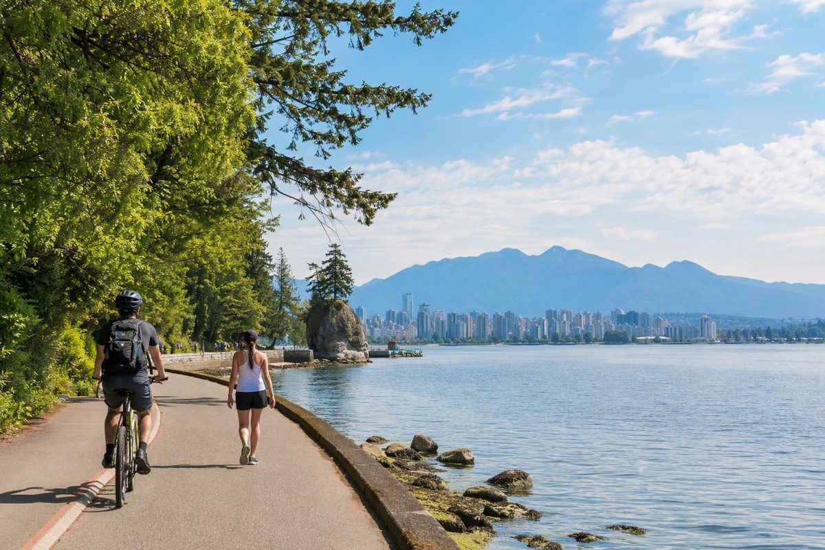
The easiest way to plan the Stanley Park Seawall is to choose the kind of outing you want before entering the park:
- Walk the full circuit if you want the freedom to linger, take photographs, visit a beach, or explore nearby attractions.
- Cycle the full circuit if covering the waterfront perimeter efficiently matters most.
- Walk a short out-and-back if time, stamina, weather, or uncertain conditions make the complete route a poor commitment.
The Stanley Park section is approximately 9 km, not the entire Vancouver Seawall. Allow about 2–3 hours to walk or 1–2 hours to cycle, before adding time for beaches, meals, attractions, and substantial photo stops. Destination Vancouver provides these route-length and timing estimates.
Related: A Vancouver Seawall Day Starts With Route Choice.
Stanley Park Seawall at a Glance
The Stanley Park Seawall follows the waterfront around the park’s perimeter. It is used for walking, jogging, cycling, and inline skating, with designated spaces for different users.
The park section belongs to a much larger waterfront network. The City of Vancouver describes a roughly 28 km seaside greenway extending from the Vancouver Convention Centre to Spanish Banks Park and calls it the world’s longest uninterrupted waterfront path. That superlative is the City’s characterization rather than an independently established record. Other route totals vary when sources use different endpoints or include different connected paths. The City’s Seawall overview distinguishes the Stanley Park section from the wider greenway.
Use these ranges to build a realistic first-visit schedule:
| Plan | Baseline time | What it includes |
|---|---|---|
| Short pedestrian out-and-back | 45–90 minutes | A waterfront sample and one or two nearby landmarks |
| Full steady walk | 2–3 hours | Continuous walking with brief pauses |
| Relaxed full walk | Half a day | Beaches, photographs, food, or nearby attractions |
| Steady bicycle circuit | About 1 hour | Riding without substantial sightseeing stops |
| Sightseeing bicycle circuit | 1.5–2 hours | Several landmark and photo stops |
These are planning ranges, not guaranteed finish times. Congestion, weather, route splits, detours, and time spent finding facilities can all extend the outing. A visit to the Vancouver Aquarium, a beach break, or a meal is not included in the basic loop estimate.
The route is generally flat and predominantly paved. Nine kilometres is still a substantial distance, the western shoreline is exposed to weather, and temporary work can introduce detours or altered surfaces. Third-party trail data describes the route as mostly rather than literally all paved and warns that freezing conditions can make paved sections slippery. AllTrails reports the surface mix and winter ice concern.
The most useful distinction is therefore not “easy versus hard.” It is continuous circuit versus flexible sample. If the distance, conditions, and available daylight suit you, the full perimeter is a manageable urban outing. If you are uncertain, begin with an out-and-back near an entrance where reversing course is simple.
Walk or Bike? Choose the Version That Fits Your Day
Walking and cycling cover the same broad waterfront perimeter but create very different days.
Walking requires no rental, return deadline, helmet fitting, or equipment management. It is easier to stop spontaneously, spend time at a beach, leave the waterfront for an attraction, or turn around. The tradeoff is time: a steady full walk normally takes 2–3 hours, while a relaxed version with several stops can occupy half a day.
Cycling is more efficient when seeing the complete perimeter matters more than lingering. A steady circuit takes about one hour, while a first-time sightseeing ride is better budgeted at 1.5–2 hours. Cyclists must also manage equipment, congestion, crossings, route splits, the marked direction of travel, and rental-return terms. A published walk-versus-bike comparison supports these timing ranges.
Do not build your schedule around an unusually fast ride recorded online. The meaningful question is not how quickly someone else completed the route, but how much time you will spend off the bicycle. Photographs, crossings, queues, beach visits, and landmark stops can quickly turn a one-hour circuit into a two-hour outing.
Four practical versions
1. Short Coal Harbour–Brockton Point out-and-back
Begin on the Coal Harbour or Georgia Street side and walk toward Brockton Point. Turn around when your time or energy reaches its halfway point. This provides harbour, skyline, and waterfront views without committing to the northern and western sides of the park.
This is the strongest option when the forecast is unstable, daylight is limited, or you have a fixed appointment later.
2. Complete 2–3 hour walk
Choose this if you are comfortable walking approximately 9 km. Keep stops brief if you need to finish within three hours. If you want a beach break, meal, or nearby attraction, extend the schedule rather than assuming you can preserve the same finish time.
3. Roughly one-hour steady ride
This suits a confident casual cyclist who wants the perimeter experience without extended stops. It leaves relatively little margin for congestion, navigation pauses, or rental delays.
4. A 1.5–2 hour sightseeing ride
This is usually the more realistic first-time bicycle plan.
A walker on a short out-and-back can reverse direction. A cyclist must not turn around and ride against the marked counter-clockwise bicycle flow. If a rider changes plans, the appropriate response is to continue with the marked flow, follow an authorized connecting route, or dismount where directed—not ride backward in the cycling lane.
Bike-rental businesses are generally concentrated near Denman and Georgia Streets outside the park. Confirm opening hours, availability, identification or deposit requirements, included equipment, return deadlines, late fees, and breakdown assistance directly with the operator. These details are changeable and should not be inferred from an older guide.
Where to Start and How to Reach the Route
For most visitors arriving from downtown or renting a bicycle, the Coal Harbour and Georgia Street side is the clearest reference start. It places cyclists into the familiar counter-clockwise sequence: Coal Harbour, Brockton Point, Burrard Inlet, the Lions Gate Bridge area, the western shoreline, Third Beach, Second Beach, and the West End side.
The Georgia Street entrance connects with the Coal Harbour Seawall and wider downtown transportation links. Visitors arriving by SeaBus or SkyTrain can continue toward the park on foot or by bicycle or transfer to transit.
Starting from downtown or Coal Harbour
Use this approach for:
- The conventional counter-clockwise cycling sequence
- A short walk toward Brockton Point
- Bicycle rentals near Denman and Georgia Streets
- A waterfront approach from downtown
- Connections from SeaBus or SkyTrain
If you are walking from central downtown, include the approach in your distance calculation. A 9 km park route becomes a considerably longer day once the walk from and back to your accommodation is included.
Starting from English Bay or the West End
English Bay is a practical pedestrian or bicycle approach for visitors staying in the West End. It works particularly well for a shorter outing focused on Second Beach, the southern shoreline, or the western side of the park.
Cyclists must pay attention to approach signs. The Stanley Park cycling route runs counter-clockwise, so the most direct-looking waterfront connection may not place you in the correct flow. Follow current pavement markings rather than assuming the path can be entered in either direction.
For walkers, English Bay supports a straightforward out-and-back toward Second Beach. Continue only as far as time, comfort, and conditions permit. This is often better than beginning a full circuit late in the day.
Arriving by bus
The number 19 bus serves two selected Stanley Park locations: one near Lost Lagoon at Stanley Park Drive and Pipeline Road, and another at the park loop near the Miniature Train and within walking distance of the Vancouver Aquarium.
Public transit does not circulate around the park perimeter. Do not expect a bus to collect you from the Lions Gate Bridge area, Skalsh/Siwash Rock, Third Beach, or another arbitrary point on the Seawall. Reaching transit from the far side may require following a signed interior connection and covering additional distance.
Bicycles are allowed on specified regional transit services, and buses have bicycle racks, but current capacity and operating rules should be checked before travel. Do not make a tight rental-return plan that depends on a rack being available on a particular bus.
Driving and parking
Drivers can enter Stanley Park from Georgia Street or Beach Avenue. Parking inside the park is paid, and the terms can differ by permit type or location. Availability, payment rules, and time limits may change.
The City’s directions page documents the park entrances, number 19 stops, regional bicycle connections, and the absence of public transit around the perimeter. Check the current Stanley Park access and parking information before departure.
Match the entrance to the outing:
- Coal Harbour: classic landmark progression or full bicycle circuit
- English Bay: short western-side walk or West End access
- Number 19 stop: waterfront segment combined with the Aquarium, Rose Garden, Miniature Train area, or Lost Lagoon
- Driving: useful for reaching a particular attraction, but not a guarantee of convenient parking beside your preferred start
A Stop-by-Stop Route Around the Park
The itinerary below follows the cyclists’ counter-clockwise direction, beginning near Coal Harbour and the Georgia Street side. Walkers can use the same order for planning, although the available official evidence does not establish a formal counter-clockwise requirement for pedestrians.
The distances are rough orientation figures measured from the Devonian Harbour Park area, not official kilometre posts. The referenced itinerary places the totem poles at approximately 1.5 km, the Girl in a Wetsuit and Lumberman’s Arch area at 3 km, Skalsh/Siwash Rock at 6 km, Third Beach at 6.5 km, Second Beach at 8 km, and Lost Lagoon at 9 km. Your reading will differ according to your actual start, route split, and mapping trace. Use these published distances only as approximate orientation.
Coal Harbour and the eastern shoreline
The opening stretch places the water on one side and marinas, skyline views, and the park edge on the other. It feels more connected to downtown than the exposed western shoreline.
Use this section to test your plan. If the weather, footwear, congestion, or bicycle fit already feels wrong, shortening the outing is easier here than after passing around the northern side of the peninsula.
Brockton Point Totem Poles — roughly 1.5 km
The totem-pole area is a major early stop and an easy place for a nominally quick ride to expand. If cycling, leave the bicycle only where permitted and move entirely out of the active lanes before viewing or photographing the site.
The area is commonly associated with visitor facilities, but no washroom, café, or shop should be treated as guaranteed open without current confirmation.
The Vancouver Aquarium, Rose Garden, and other inland attractions are not simply consecutive waterfront stops. Reaching them requires leaving the immediate Seawall circuit or using connecting paths, so budget separate time.
Brockton Point Lighthouse and nearby landmarks
Continue around Brockton Point toward the lighthouse area. Pedestrian and bicycle alignments can diverge, so watch the signs rather than automatically following the nearest person.
The scenery changes here. The downtown-facing harbour gives way to broader views across Burrard Inlet, including marine traffic, the North Shore, and mountain slopes.
Nearby sights can include the Nine O’Clock Gun, the Girl in a Wetsuit sculpture, Lumberman’s Arch, and other monuments or recreation spaces. Not every feature sits directly beside the same lane, and stopping for all of them adds considerable time.
Girl in a Wetsuit and Lumberman’s Arch area — roughly 3 km
This is a useful second decision point. A cyclist is still relatively early in the complete circuit. A walker has already accumulated meaningful distance from the Coal Harbour side, and returning by the same route creates a substantial out-and-back.
Beyond this area, the route continues beside Burrard Inlet. The emphasis shifts from the urban harbour toward water, mountain views, and the approach to the Lions Gate Bridge.
Lions Gate Bridge and the northern side
The Seawall passes through the bridge area at water level while the bridge rises above the narrows. Expect changing sightlines rather than one formal viewpoint. Trees, shoreline curves, infrastructure, and light conditions all affect what is visible.
This is where some first-time visitors underestimate the outing. Downtown may still appear geographically close, but the practical perimeter route continues around the western shoreline before reaching the beaches and West End.
Skalsh/Siwash Rock — roughly 6 km
Visitor sources commonly identify the prominent sea stack as Siwash Rock; some also use Skalsh. Naming conventions and orthographies vary. Use the name presented on current on-site interpretation, and avoid repeating cultural stories unless they come from an authoritative Indigenous source.
At approximately 6 km from the stated orientation point, the landmark also signals that a walker is well committed to the perimeter. Depending on the intended destination and any closure, returning the way you came may now be longer than continuing. Follow current signs instead of improvising through interior trails.
Wind, incoming weather, and cooler conditions may be more noticeable, even when downtown feels sheltered.
Third Beach — roughly 6.5 km
Third Beach can be a brief rest, a picnic stop, or a destination in itself.
A beach visit changes the schedule. Leaving the route, finding a place to sit, eating, using facilities, and returning to the path can turn a nominal pause into a substantial break. If completing the loop is the priority, decide how long you want to stay before stopping.
Washrooms and seasonal services have been reported here, but their availability can vary. Carry water rather than assuming every facility will be operating.
Second Beach — roughly 8 km
The environment becomes more recreational as you approach Second Beach and the English Bay side. Compared with the more exposed western shoreline, this area has beach, picnic, playground, and park-facility activity.
Second Beach is associated with washrooms, picnic space, playgrounds, a snack facility, and a public pool. All are date-sensitive: seasonal schedules, maintenance, events, and temporary closures can affect access.
This is also a logical exit for visitors staying in the West End.
English Bay, the West End and Lost Lagoon — roughly 9 km
From Second Beach, follow the current signs for your mode of travel. Pedestrians can continue toward the English Bay and West End waterfront network or use an appropriate signed connection toward Lost Lagoon and the park entrance. Cyclists should remain in the marked counter-clockwise flow and follow the signed route rather than taking an improvised shortcut.
Reaching it may involve leaving the strict waterfront alignment.
The approximate 9 km figure does not guarantee that your watch will display exactly 9 km when you finish. Different traces may begin or end near Devonian Harbour Park, Lost Lagoon, English Bay, a rental shop, a hotel, a bus stop, or a parking area. Returning to the exact doorway, shop, or marker where you began can add distance beyond the standard park-section estimate.
The baseline travel time is a movement estimate, not a complete sightseeing itinerary. Add time separately for every beach, meal, attraction, interpretive stop, and extended photography session.
Lane Rules, Direction and Low-Stress Seawall Etiquette
The Stanley Park route uses designated spaces for different users:
- Pedestrians and joggers: use the lane closest to the water.
- Cyclists and inline skaters: use the designated inside lane.
- Cyclists: travel counter-clockwise around the Stanley Park section.
The available official evidence clearly establishes counter-clockwise travel for cyclists. It does not establish the same formal one-way rule for pedestrians; tourism guidance states that walkers can travel in either direction. Current signs and pavement markings take precedence over any static description. Destination Vancouver summarizes the lane arrangement and direction rules.
Separated lanes do not eliminate conflict. Routes can split near landmarks, users may cross one another’s path, curves can limit visibility, and visitors sometimes stop suddenly while interpreting markings. Treat every split and crossing as a decision point.
For cyclists
- Enter and remain in the counter-clockwise flow.
- Use a controlled speed appropriate for congestion and sightlines.
- Leave enough room to respond to children, stopped users, crossings, and route changes.
- Never stop abruptly in the riding lane for a photograph or map check.
- Pull entirely clear of the active lane before stopping.
- Pass only where markings and conditions make it appropriate.
- Obey posted slow, no-passing, dismount, and detour instructions.
- At an unclear split, slow down and read the sign rather than blindly following another rider.
- If you need to reverse course, dismount or use an authorized connection instead of riding backward.
This guide does not publish a numerical speed limit or a permanent list of dismount locations because those operational instructions require current official verification.
For inline skaters
Use the designated inside lane and follow all current pavement markings and posted directional instructions. Do not assume that a formal rule stated specifically for cyclists necessarily applies identically to every other wheeled user; on-site signs govern.
For walkers and runners
- Stay in the waterside pedestrian lane unless a sign directs otherwise.
- Look for bicycle traffic before crossing the cycling side.
- Keep groups from spreading into both lanes.
- Keep children close at crossings and congested landmarks.
- Step completely out of the travel lane for photographs.
- Avoid stopping immediately after a blind curve.
- If walking against the prevailing visual flow, be especially attentive at narrow points and crossings.
A painted line is not a physical barrier. Low-stress use depends on predictable movement: hold your line, check before crossing, and make stops away from active travel space.
Facilities, Families and Accessibility: What to Verify
The Stanley Park Seawall is an urban route, but services are not continuous. Washrooms, water fountains, benches, food, beaches, playgrounds, and recreation facilities are concentrated at selected locations.
Commonly reported facility points include:
- The Brockton Point totem-pole area
- Third Beach
- Second Beach
- Inland attractions and recreation areas reached by connecting paths
Second Beach is the most substantial facility cluster in many itineraries, with washrooms, picnic space, playgrounds, a snack facility, and a public pool. Third Beach and the totem-pole area are also associated with washrooms or seasonal visitor services. A detailed Stanley Park itinerary identifies these facility clusters.
Do not assume that a listed service will be open on your visit. Carry enough water to bridge gaps, especially in warm weather or when fountains may be shut down. If a washroom is medically or practically essential, verify more than one suitable option before starting.
Flat does not mean short
The route’s modest grade can help families, stroller users, and many mobility-device users. Grade, however, is only one component of accessibility. The full outing also involves:
- Approximately 9 km of travel
- Exposure to wind, rain, heat, or cold
- Congestion and lane crossings
- Potentially slippery or altered surfaces
- Limited shortcuts after committing to the far side
- Detours that may have different grades or surfaces
- Distance between rest points and dependable services
Tourism and trail sources describe the route broadly as wheelchair- and stroller-friendly. Those labels are useful starting signals, not a barrier-free guarantee for every entrance, device, user, or day. AllTrails lists wheelchair- and stroller-friendly attributes but does not provide a section-by-section accessibility audit.
Accessibility checklist
Before relying on the route, confirm:
- Closures and detours: A standard Seawall description does not establish the grade or surface of a temporary interior diversion.
- Surface conditions: Check for ice, storm debris, construction plates, gravel, pooled water, or damaged pavement.
- Accessible washrooms: Confirm their location, operating hours, and current access route.
- Curb and crossing transitions: Review the exact entrance and exit you intend to use.
- Rest opportunities: Identify benches, sheltered areas, and realistic turnaround points.
- Device requirements: Consider width, turning space, battery range, slope tolerance, and assistance needs.
- Return plan: Know how you will reach transit, a vehicle, or accommodation if the complete route becomes impractical.
For families, the best outing is not necessarily the full circuit. A Coal Harbour–Brockton Point walk, an attraction-plus-waterfront segment, or a Second Beach visit may be more enjoyable than asking everyone to complete 9 km.
The same principle applies to slower visitors or anyone uncertain about stamina. Choose a defined segment with a clear turnaround point rather than treating a broad “easy” classification as proof that the full route suits everyone.
Dog access, leash requirements, and location-specific restrictions should be checked against current official park rules. Third-party trail labels are not sufficient authority for determining where a dog may go.
Crowds, Weather, Closures and a Backup Plan
Sunny summer days and weekends can be busy, particularly near entrances, beaches, landmarks, and crossings. An early weekday start may reduce congestion, though no time guarantees a quiet route.
Build a buffer into any schedule with a firm deadline.
Winter presents different concerns. Freezing conditions can create slippery surfaces, while shoreline storms may bring wind, waves, debris, and harsh exposure. A route described as available throughout the year should not be assumed continuously safe or unobstructed.
The City documents recurring winter maintenance that can temporarily affect the section between Prospect Point and Third Beach and the area at Ferguson Point. Work has included rock scaling, vegetation and debris removal, drainage clearing, power washing, and inspection of rockfall-protection netting and anchors. The City’s page explains the maintenance pattern but does not provide live status merely because you are reading it now. Check the City of Vancouver’s Seawall information and current notices immediately before departure.
Pre-visit check
Review:
- Official pathway closures, warnings, and detours
- Hourly weather rather than only a daily icon
- Temperature and the possibility of ice
- Wind and storm conditions on the western shoreline
- Sunset and usable daylight
- Transit schedules and bicycle-carrying rules
- Parking availability and payment terms
- Rental inventory, return deadline, and breakdown policy
- Washroom, fountain, concession, pool, and attraction availability
If conditions change
Do not pass a closure barrier because other users appear to be doing so. Follow the posted detour, even if it adds distance, grade, or a different surface.
Carry water and a rain layer. In cooler conditions, bring enough warmth for slower movement or an unexpected stop. A bicycle problem on the far side can turn a short ride into a long walk.
If weather is deteriorating or daylight is becoming marginal, do not start the complete circuit. Choose a short out-and-back near Coal Harbour, English Bay, Second Beach, or another defined entrance.
Short pedestrian sections are easy to control because you choose the turnaround point. Once you commit to the northern or western perimeter, direct exits become less obvious. Use an official map and follow posted instructions rather than drawing a straight line across the park.
A useful backup plan has three levels:
- Plan A: Complete waterfront circuit
- Plan B: Short waterfront out-and-back
- Plan C: Lost Lagoon, a nearby attraction, or a sheltered park-edge walk without committing to the perimeter
Choose these alternatives before leaving, not after you are cold, tired, or behind schedule.
Why the Seawall Exists—and Why Its Completion Has Two Dates
“Seawall” can refer to two related things: the physical stone structure created to protect the shoreline and the recreational pathway associated with it. They are not identical. The connected path extends beyond Stanley Park, and not every section is necessarily built directly on top of the stone wall.
The wall originated as erosion-control infrastructure intended to protect Stanley Park’s foreshore. Construction began in 1917 and continued incrementally for decades as funding and shoreline priorities allowed. Master stonemason James Cunningham became closely associated with the project and oversaw much of its long-running construction.
That extended history explains why both 1971 and 1980 appear as completion dates:
- 1971: The last block associated with the original seawall vision was placed.
- September 1980: The Stanley Park loop was officially completed after final paving between Third Beach and Second Beach.
These dates describe different milestones rather than irreconcilable claims. A historical account of the Vancouver Seawall distinguishes the erosion-control wall, the path, the last-block milestone, and the later completion of the park loop. The documented construction chronology explains the 1971 and 1980 dates.
The result is infrastructure with a second identity. A wall built to protect the foreshore became the foundation and companion of a route used for walking, running, cycling, and skating.
Frequently Asked Questions
How long is the Stanley Park Seawall, and how long does the loop take?
The Stanley Park section is approximately 9 km. Allow about 2–3 hours to walk, roughly one hour for a steady bicycle circuit, or 1.5–2 hours for a sightseeing ride. Add more time for beaches, photographs, meals, attractions, crowds, and detours. These timing ranges are summarized in a published walking-and-cycling comparison.
Do not confuse the park circuit with Vancouver’s broader waterfront network, which the City describes as approximately 28 km between its stated endpoints.
Do pedestrians and cyclists both have to travel counter-clockwise?
Cyclists must travel counter-clockwise around the Stanley Park Seawall. The available official evidence does not establish the same formal one-way requirement for pedestrians; walkers should remain in pedestrian space and follow current signs.
Pedestrians and joggers use the lane closest to the water. Cyclists and inline skaters use the designated inside lane. Posted signs and pavement markings take priority over general guidance.
Can I do only part of the Stanley Park Seawall?
Yes. A short pedestrian out-and-back from Coal Harbour toward Brockton Point is one of the simplest first-visit options. Visitors near English Bay can also plan a shorter outing around Second Beach and the western approach.
Set a turnaround time before starting. Short sections are easiest near an entrance because convenient exits and shortcuts become less obvious on the far side. Cyclists cannot reverse and ride against the counter-clockwise flow.
Is the Stanley Park Seawall wheelchair- and stroller-accessible?
Tourism and trail sources describe the generally flat, predominantly paved route as suitable for many wheelchair users and strollers. That does not establish that every entrance, crossing, washroom, surface, or temporary detour is barrier-free.
Check closures, detour grades, surfaces, curb transitions, accessible washrooms, rest spacing, and the requirements of the specific mobility device. A shorter segment may be more suitable than the complete circuit.
How do I check current Seawall closures and detours?
Consult current City of Vancouver or Park Board notices immediately before leaving, then follow the signs encountered in Stanley Park. Check again after severe weather or during the winter maintenance period.
Your pre-departure review should also cover weather, daylight, transit, parking, facility availability, and bicycle-rental return times. If a section is closed, do not pass the barrier; use the posted detour or switch to a shorter outing.
The Simple Planning Formula
Decide first whether you want a short waterfront sample or the full 9 km circuit. Reserve 2–3 hours for walking or 1–2 hours for cycling, then add separate time for every beach, meal, attraction, and substantial photo stop.
Use the correct lane, follow the counter-clockwise bicycle flow, and check official conditions immediately before leaving. If you want to connect Stanley Park with Coal Harbour, English Bay, False Creek, or other waterfront neighbourhoods, use Vancouver Know’s broader guide to planning a Vancouver Seawall day to choose between a loop and a one-way route.