
How to Plan a Beach-Centred Day on Vancouver’s West Side
Plan a coherent first visit as a sequence: waterfront time at Kitsilano Beach, a manageable walk or ride, and one well-chosen commercial corridor.
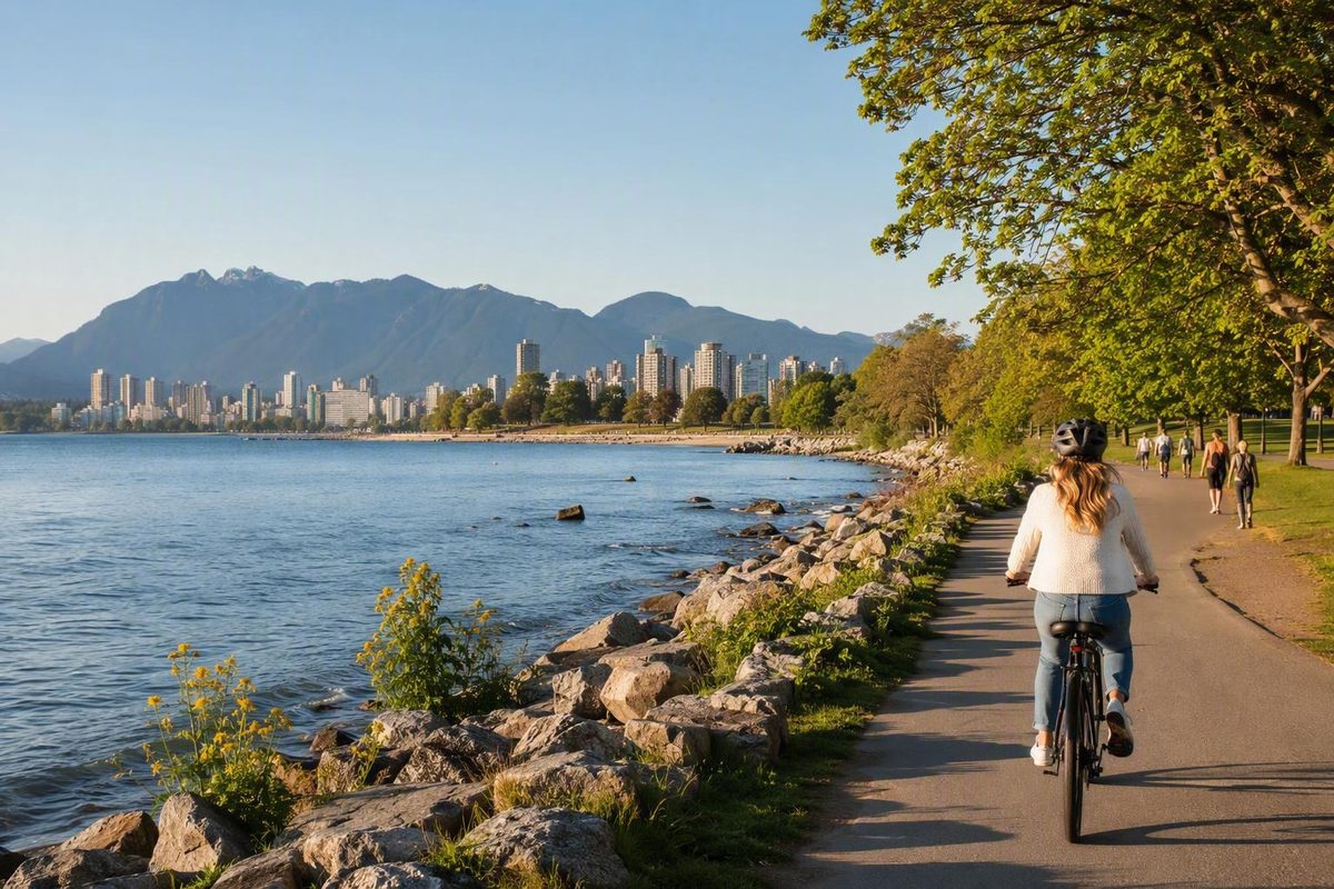
Kitsilano makes more sense as a sequence than as a list of attractions. Start at the waterfront, walk or ride a manageable section of the shoreline, then choose one commercial street for food or shopping. That structure gives a first-time visitor the neighbourhood’s essential mix: beach recreation, residential streets and local commercial life.
Commonly called Kits, Kitsilano is a primarily residential neighbourhood on the south shore of English Bay, on Vancouver’s west side. It is a strong choice for visitors who value outdoor time and neighbourhood atmosphere. It is less suited to anyone expecting a dense concentration of major sights, all-weather attractions or nightlife within a few blocks.
The main planning complications are practical. Beach and pool services are seasonal, the broader cycling network includes hills and unpaved sections, parking can be constrained, and informal definitions of the neighbourhood vary. Use Kitsilano Beach as your anchor, add West 4th Avenue or West Broadway—not both unless you have ample time—and verify changeable operating details before leaving.
Kitsilano at a glance: where it is and how to read the neighbourhood
Kitsilano occupies part of Vancouver’s west side along the south shore of English Bay. A commonly cited orientation places English Bay to the north, Burrard Street to the east, Alma Street to the west and 16th Avenue to the south. Treat that as a planning box rather than an uncontested definition. Some local descriptions stop at Macdonald Street in the west or West Broadway in the south, as reflected in Scout Magazine’s discussion of Kitsilano’s boundaries.
For a visitor, it is more useful to think in zones:
- Kits Point and Kitsilano Beach: The main waterfront area, with park space, recreation, paths and views.
- West 4th Avenue: The commercial corridor that pairs most naturally with a beach outing.
- West Broadway: A broader, more everyday commercial street farther south.
- Yew Street and Cornwall Avenue: Beach-adjacent options for a short food or refreshment stop.
- Residential Kitsilano: Quieter blocks between the main corridors, useful for experiencing the neighbourhood’s character but not filled with conventional attractions.
These zones are connected, but they do not form one continuous visitor strip.
Boundary uncertainty also affects attraction lists. A museum, park, beach or restaurant may be marketed as “in Kitsilano” because it is nearby or easy to combine with a Kits visit. That does not establish that it lies within the neighbourhood’s commonly understood limits. Treat Vanier Park, Granville Island, Jericho Beach and nearby cultural sites as optional adjacent destinations whose exact addresses should be checked.
The simplest decision summary is this: visit Kitsilano primarily for waterfront recreation, neighbourhood walking, shopping and dining. If your priority is moving quickly among numerous major downtown sights, Kits is better approached as one focused outing than as another sightseeing district to rush through.
The name and the history visitors should understand
The name Kitsilano derives from X̱ats’alanexw, the Squamish name associated with Chief August Jack Khatsahlano. The namesake is only an entry point into the area’s history. Kitsilano and the surrounding shores have long-standing connections to the Musqueam, Squamish and Tsleil-Waututh peoples that predate the incorporation and development of Vancouver, as summarized by Destination Vancouver’s neighbourhood overview.
The available secondary historical account identifies a former Squamish village site and says that False Creek Indian Reserve No. 6 was established there by the colonial government in 1869. It describes residence, ceremony, trade, fishing and cultivation, followed by progressive occupation or appropriation of reserve land, forced relocation and the Squamish Nation’s later recovery of a small portion of the former reserve through legal proceedings. However, the source also contains citation gaps and contradictory passages about particular transactions. It cannot support a definitive parcel-by-parcel account of surrender, sale or appropriation, so those details should not be inferred from this bounded secondary account of Kitsilano’s history.
That limitation is important. A visitor guide should neither erase displacement nor pretend to settle a complex legal and historical record using an inconsistent secondary source. The responsible orientation is narrower: Indigenous life here encompassed far more than the person after whom the neighbourhood was named, and continuing connections to the area exist alongside a history of colonial reserve creation, displacement and partial land recovery. A definitive account of Senakw and the former reserve requires Nation-led materials, primary records, legal decisions and authoritative scholarship beyond the scope of this itinerary.
Settler-era development later involved logging, farming, railway expansion, streetcars, bridge construction and successive waves of residential building. These changes should not be presented as a seamless progression from forest to suburb, because that framing obscures Indigenous displacement and the varied communities involved in the neighbourhood’s development.
Those communities included early South Asian settlers working near the False Creek sawmills. The supplied historical account reports that a Sikh temple opened in Kitsilano in 1908 and served that community. It also reports that Greek immigration later influenced the business community along West Broadway, particularly west of Macdonald Street. Both points come from the same limited secondary history of Kitsilano and should be treated as a concise orientation rather than a complete community history.
For visitors, the practical lesson is simple: Kitsilano’s contemporary waterfront appeal sits within a much older and more complicated landscape. Acknowledging that context need not overwhelm a beach day, but it should prevent the neighbourhood’s history from being reduced to a casual namesake note.
Kitsilano Beach: the practical centre of a visit
Kitsilano Beach is on Cornwall Avenue at the north end of Yew Street. The Seaside Seawall runs beside it, allowing the beach to work as a destination, a rest point on a longer walk or ride, or the centre of a compact neighbourhood outing.
The City lists public washrooms, a concession, tennis and basketball courts, a playground, a swimming raft and pay parking. Kitsilano Pool is on the west side of the beach. Lifeguards and a water wheelchair are listed as seasonally available from approximately Victoria Day to Labour Day; the wheelchair requires two attendants. Fishing and harvesting bivalve mollusks, including clams, oysters and mussels, are prohibited. Current availability and rules must be confirmed through the City of Vancouver’s Kitsilano Beach information.
Common beach-area activities include:
- Walking or cycling beside the waterfront
- Swimming when conditions and seasonal supervision allow
- Playing tennis or basketball
- Playing or watching beach volleyball
- Paddleboarding
- Relaxing or sunbathing in the beach and park area
- Watching the evening light and sunset
- Pairing a shoreline walk with a nearby meal
You do not need to be active to justify the trip. The park, water and views are enough for a low-key visit, particularly when combined with a short walk and food near Yew Street, Cornwall Avenue or West 4th Avenue. More active visitors can make the beach one segment of a longer waterfront ride.
The appealing images of sand, mountains and sunsets do not tell the whole practical story. Individual visitors have reported very cold water, rocks or shells mixed into the beach surface and difficulty finding convenient parking. These are personal experiences, not guaranteed conditions, but they support sensible precautions: bring suitable footwear, do not assume the ocean will feel warm on a sunny day, and avoid building a tight schedule around finding a parking space. The observations appear among traveller reports about Kitsilano Beach.
Seasonal lifeguarding does not guarantee that supervision will be available at the time of your visit. If supervised swimming matters, confirm the current status before departure and keep a non-swimming plan available.
The listed water wheelchair is useful for advance planning, but its presence does not establish that every part of the route—from arrival and parking to paths, washrooms, sand, water or pool—will meet an individual visitor’s needs. Confirm availability, attendant requirements and the complete arrival-to-activity route directly with the City.
Drivers should similarly treat pay parking as an amenity, not a guarantee of a convenient space. EasyPark manages the referenced beach and park lots, but rates, limits and payment arrangements can change. On busy beach days, an inflexible parking plan can consume a disproportionate amount of the visit.
Kitsilano Pool and other seasonal details to verify
Kitsilano Pool is an outdoor saltwater pool on the west side of Kitsilano Beach. Its waterside setting makes it a recognizable local facility, but it is seasonal rather than a stable year-round attraction. Opening dates, hours, admission arrangements, maintenance closures and accessibility provisions can change within or between seasons.
A City notice dated May 4, 2026 said the pool was targeting a mid-June opening after seasonal maintenance and final inspections. That was a target, not confirmation that the pool subsequently opened, and it should not be used as current operational information. Check the latest facility status before departure. The same City beach page also contains dated policy material rather than one unambiguous alcohol rule for every current visit, so no present-day rule should be inferred from an old announcement; consult the City’s current beach information and linked notices.
Different guides have described Kitsilano Pool using inconsistent superlatives, including claims that it is the longest, largest or formerly largest saltwater pool in North America. The supplied evidence does not substantiate those comparisons consistently. The accurate and useful description is narrower: it is a seasonal outdoor saltwater pool beside Kitsilano Beach.
Pre-visit checklist
Before leaving for the waterfront, verify:
- Pool status: Is Kitsilano Pool operating on the day of your visit?
- Hours and admission: What are the current hours, entry arrangements and fees?
- Lifeguard coverage: Will the beach be supervised when you intend to swim?
- Weather: Will temperature, wind or rain change the outing?
- Beach advisories: Are any water-quality or operational notices in effect?
- Parking: What rates, restrictions and payment methods currently apply?
- Regulations: Have beach, park or alcohol rules changed?
- Accessibility: Are the required facilities available, and has the complete route been confirmed?
- Water wheelchair: If needed, is it available and can its operating requirements be met?
The broader principle is to separate stable orientation from changeable operations. The beach’s location, the relationship between the pool and waterfront, and the arrangement of the main commercial corridors are relatively stable. Pool openings, lifeguard coverage, fees, advisories, parking rules and accessibility arrangements are not.
Build a day that still works if swimming is unavailable. A waterfront walk, park time, residential streets and one commercial corridor can carry the outing. Treat the pool as a seasonal option rather than the feature on which the entire day depends.
West 4th, West Broadway, Yew, and Cornwall: choosing the right street
West 4th Avenue and West Broadway are Kitsilano’s two principal commercial corridors, but they suit different outings. Yew Street and Cornwall Avenue provide smaller, beach-adjacent alternatives. Choosing in advance prevents needless zigzagging.
West 4th Avenue is usually the most natural addition to a first beach visit. It offers shops, restaurants, outdoor-oriented retail and neighbourhood activity. The transition from waterfront to residential blocks and then to a commercial street also reveals more of Kitsilano than staying exclusively beside the water.
West Broadway is broader and more functional in character, with restaurants, shops and everyday services along a major east–west corridor. The supplied historical material also associates the area west of Macdonald Street with Greek influence. Choose Broadway when the corridor itself interests you, when your accommodation or onward route places you nearby, or when you want an everyday commercial environment rather than the closest extension of a beach visit.
Do not treat West 4th and West Broadway as one continuous visitor strip. Both can fit into a full day, but there is rarely a reason to move repeatedly between them.
Yew Street and Cornwall Avenue are better for a short stop near the waterfront. They suit visitors who want food or a drink without turning the day into a wider shopping excursion. Their role is beach-adjacent convenience, not replacement for the two larger corridors.
Business recommendations age quickly. Editorial neighbourhood guides may combine established businesses with places that have closed, moved or changed hours. This guide therefore does not present any named restaurant or shop as currently operating. Check the exact address and the business’s own information on the day of your visit.
Any business example added to an itinerary should carry the date on which its status was verified. Undated hours, rankings and claims about signature dishes should be removed rather than repeated as permanent facts. Corridor-based advice remains useful even as individual businesses change.
A simple choice framework works well:
- Beach plus shopping or a wider restaurant choice: West 4th Avenue
- A broader commercial street or interest in the area’s Greek influence: West Broadway
- The shortest practical food stop near the beach: Yew Street or Cornwall Avenue
- Limited time or energy: Stay near the waterfront
- Full-day visit: Add one main corridor, then consider another only if time and interest remain
The goal is not to cover the most ground. It is to create a coherent progression from waterfront recreation to neighbourhood life.
Walking and cycling Kitsilano without overcomplicating the day
The simplest car-free strategy is to treat Kitsilano as a cluster-based outing: waterfront first, then one commercial corridor. This avoids spending the day on repeated north–south transfers or unnecessary cross-city moves.
Burrard Bridge connects the Kitsilano side of False Creek with central Vancouver and can form part of a walking or cycling approach. The bridge is a connection, however, not proof that every downtown attraction is immediately beside Kitsilano Beach. Account for the full distance from your starting point and for the effort of the crossing.
For cyclists, the City’s featured Seaside Vancouver route provides a broader framework. The route passes through the Kitsilano area between False Creek, Spanish Banks and the downtown side of Burrard Bridge. It is 25.3 kilometres long, rated medium difficulty and primarily uses separated bicycle paths. The estimated riding time is two hours and 30 minutes at an average speed of 12 kilometres per hour, before rest and sightseeing stops. The City advises allowing up to one additional hour for stops. The route includes steep sections around Kitsilano, Point Grey and Burrard Bridge, and nearly one quarter consists of gravel or other unpaved surfaces, according to the City’s cycling routes and maps.
Those figures describe the complete featured route, not a required Kitsilano itinerary. Most first-time visitors can ride a shorter waterfront segment and still gain a clear sense of the neighbourhood.
Review the current cycling map before setting out. Consider surfaces, gradients, connections and where you intend to leave the waterfront for food. If riding with people of mixed abilities, let the least confident rider determine the distance and turnaround point. A shorter out-and-back ride may be more enjoyable than forcing completion of the entire route.
Walking benefits from the same restraint. Choose one manageable waterfront section, pause at the beach and then move inland once. If West 4th is your finish, there is no need to return to the water unless your departure plan requires it. If the beach is the primary destination, use Yew Street or Cornwall Avenue for a nearby stop instead of adding a longer southern detour.
A useful car-free structure is:
- Use current official trip-planning information to plan your arrival in Kitsilano.
- Begin with the beach or waterfront while energy is highest.
- Walk or ride only the distance that suits your ability and schedule.
- Leave the waterfront once for your chosen meal or shopping corridor.
- Plan the return journey from that corridor rather than automatically retracing the whole route.
Plan the arrival and departure as separate legs. The most convenient way to reach the beach may not be the most convenient way to leave West 4th or West Broadway. Current bus routes, frequencies and travel times are deliberately not reproduced here because the supplied evidence does not establish a reliable current list.
This cluster approach reflects Vancouver Know’s broader focus on neighbourhood choice, car-free movement and manageable seawall days. Its planning article index provides related frameworks without implying that every Vancouver itinerary needs to include Kitsilano.
Should you stay in Kitsilano or visit it for the day?
Kitsilano can be a useful trip base, but only for a particular kind of visit. The decision is less about whether the neighbourhood is universally “best” and more about what you want close to your accommodation each morning and evening.
It is most likely to suit visitors who prioritize:
- A beach-oriented routine
- Walking, cycling or outdoor time
- Residential streets rather than a dense central district
- Neighbourhood restaurants and shops
- Quieter evenings rather than a strong nightlife focus
- A slower trip with fewer daily cross-city moves
The central trade-off is location. Reaching downtown requires a planned connection, potentially involving Burrard Bridge. Some editorial visitor sources consider central neighbourhoods more convenient for broad car-free exploration because downtown attractions and regional connections are closer together. That is an opinion rather than a measured verdict, but it reflects a genuine geographic choice. One editorial accommodation comparison characterizes Kitsilano as beach-oriented and local in feel while treating central Vancouver as a more generally convenient visitor base.
That may be an advantage if you want a residential return point after a day out. It may be a drawback if your itinerary centres on late-night entertainment or if you expect a dense concentration of venues immediately outside your accommodation.
The supplied evidence is not sufficient to establish a complete, current inventory of hotels or other lodging. Do not conclude that Kitsilano has no hotels, and do not assume that a particular lodging type will be available.
Always verify an accommodation’s exact address before booking. Commercial and informal listings may apply the Kitsilano label more broadly than local boundary definitions. Measure the actual distance to the places you expect to use: Kitsilano Beach, West 4th, West Broadway, your preferred downtown connection and any regional transport links.
Avoid choosing on unsupported generalizations about safety, family suitability, affordability or transit quality. Instead, ask:
- How many days will focus on downtown attractions?
- How often will you return to your accommodation during the day?
- Is beach access central to the trip or only one planned outing?
- Are you comfortable with longer connections and bridge crossings?
- Do you want active evenings or a residential return point?
- Does the exact accommodation address fit your daily route?
Kitsilano can suit a beach-focused stay built around outdoor time and neighbourhood life. Visitors prioritizing immediate access to downtown attractions and regional connections may find it easier to stay centrally and visit Kits as a half- or full-day outing.
A simple half-day or full-day Kitsilano plan
A useful Kitsilano itinerary should survive a closed pool, cool weather or an unexpectedly long meal. The beach is the anchor; everything else is an optional extension.
Half-day framework
Begin at Kitsilano Beach. Spend time orienting yourself to the park and waterfront before deciding how far to walk. If swimming matters, check current pool and lifeguard information before arrival.
Walk a waterfront section that fits the weather, your mobility, your footwear and whether you need to retrace the route. The purpose is to experience the shoreline, not to reach an arbitrary turnaround point.
Then choose one finish:
- Continue inland to West 4th Avenue for a larger commercial stretch.
- Stay near Yew Street or Cornwall Avenue for a shorter food stop.
- Remain in the park if the waterfront itself is the priority.
The exact duration will depend on swimming, court use, shopping and how long you stop for food. It need not follow a rigid timetable.
Full-day framework for active visitors
Enter through a planned connection, potentially including Burrard Bridge, and follow part of the Seaside route toward or through Kitsilano. Pause at the beach for recreation, rest or a meal. Include the pool only after confirming that it is operating.
After the waterfront, add one main commercial corridor:
- Choose West 4th for the most direct beach-to-shopping sequence.
- Choose West Broadway when its broader commercial character or western Greek influence is a specific interest.
The complete Seaside route is optional. It may suit prepared cyclists, but it is not necessary for experiencing Kitsilano. Riders considering the full route should account for its official riding estimate, additional stopping time, hills and unpaved sections.
Low-energy alternative
Centre the outing on the beach park and views. Check current path conditions, choose a short waterfront segment, spend time sitting in the park and finish with a nearby meal.
This version avoids an extended bridge crossing and the pressure to reach West Broadway. It can still provide a strong sense of Kitsilano because the waterfront is the neighbourhood’s clearest visitor anchor.
Visitors with mobility requirements should verify parking or drop-off arrangements, washrooms, path surfaces, slopes and any pool or water-wheelchair requirements in advance. An individual accessible feature does not guarantee that every transition in the outing will work.
Non-swimming or cooler-weather version
Use the shoreline as a walking and viewing route rather than a swimming destination. Continue through nearby residential streets and finish on West 4th or West Broadway.
This version works when the pool is closed or swimming is unappealing, but it is not a complete rainy-day attraction plan. Much of Kitsilano’s visitor appeal remains outdoors. In wet or windy weather, shorten the waterfront section and allow more time for the chosen commercial corridor. Verify any indoor business before depending on it for shelter.
Nearby museums and attractions can be added separately, but check their exact addresses rather than assuming they lie within Kitsilano proper.
Final departure checklist
Before setting out:
- Confirm the pool’s current status, hours and admission arrangements.
- Confirm current lifeguard coverage if swimming is planned.
- Check weather and any beach advisories.
- Review the current cycling map if travelling beyond the immediate beach.
- Verify parking rates and alternatives if driving.
- Check the exact address and current hours of any business you intend to visit.
- Confirm accessibility arrangements directly.
- Allow extra time for hills, route-finding, rest stops and views.
- Treat adjacent attractions as optional additions and verify their locations.
Kitsilano is easiest to understand as a sequence: waterfront time at Kitsilano Beach, a manageable walk or ride, and one well-chosen commercial corridor. It is particularly rewarding for visitors who value beaches, outdoor activity and residential neighbourhood atmosphere. Its limitations are equally clear: seasonal operations, hills, variable boundaries, parking pressure and less immediate access to central Vancouver.
Before departure, verify current City information for the pool, lifeguards, parking, accessibility arrangements and beach rules.
What is Kitsilano best known for?
Kitsilano is best known for its beach-centred west-side setting. Kitsilano Beach, the adjacent park and pool, and waterfront paths form the main visitor focus.
Beyond the water, the neighbourhood is associated with residential streets and the commercial corridors of West 4th Avenue and West Broadway. A useful first visit combines the beach with one of those streets.
Where does Kitsilano begin and end?
A common orientation places Kitsilano between English Bay, Burrard Street, Alma Street and 16th Avenue. Informal definitions vary, with some descriptions using Macdonald Street as the western edge or West Broadway as the southern edge.
Verify exact addresses rather than relying on a place simply being advertised as “Kitsilano,” especially near the neighbourhood’s western and southern margins.
Can you visit Kitsilano without a car?
Yes. Kitsilano works well as a focused walking or cycling outing when organized by clusters: waterfront first, followed by one commercial corridor.
Plan the arrival and departure separately using current trip-planning information. Do not assume that every part of the wider waterfront network is flat, paved or immediately adjacent.
Is Kitsilano Pool open year-round?
No. Kitsilano Pool is a seasonal outdoor saltwater pool. Its opening status, hours, admission arrangements, maintenance condition and accessibility provisions must be confirmed before visiting.
Do not rely on an earlier target opening date as evidence of current operations.
How much time should you spend in Kitsilano?
Allow roughly a half day for the beach, a manageable waterfront walk and one food or shopping stop. A full day suits visitors who want a longer ride, substantial beach time, confirmed swimming or more time on West 4th or West Broadway.
A low-energy outing can consist of park time, views, a short walk and a nearby meal. The full Seaside cycling route is optional rather than necessary.